The system we have designed to explore the dimensional stacking technique has been called, with all due respect to Edwin Abbott (18), N-Land. N-Land in its current form can be likened to a type of manual projection pursuit, with some capabilities to undertake the ``Grand Tour'' of the data. N-Land allows any arbitrary orthogonal view of a data set to be specified by selecting pairs of dimensions in a horizontal/vertical orientation and arranging them according to hierarchical levels, or speeds (see LeBlanc et. al. (4)). This results in a unique mapping of the high-dimensional space down to a two-dimensional space, which allows the innate human visual pattern recognition ability to be utilized in the data analysis. View selection may be made in a ``random access'' manner or by sequencing through all possibilities. Images exceeding the screen resolution may be examined with a scrolling mechanism.
Once an orthogonal view is specified, rotational adjustments can be made via either a rotation process on continuous data or a shearing process on discrete data. This procedure operates on pairs of dimensions as specified by the user. Arbitrary subspaces of the data set can also be viewed by specifying a viewing region (analogous to clipping techniques in graphics). The user may also invoke a number of data enhancement operations, such as thresholding, segmentation, smoothing, and boundary detection. Finally, a utility is provided for examining quantitatively the individual data values in a given mapping. Details of some of these capabilities of N-Land are presented below.
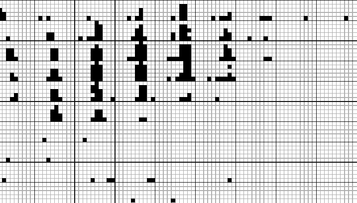
Figure 2 shows an example of a four-dimensional display. In this case there is no dependent variable and data points are simply mapped to black squares. This set of data consists of three spatial dimensions and a fourth dimension representing the grade of iron ore at the location specified by the spatial coordinates. The data was generated by drilling a number of holes in the ground at various positions and recording the ore grade at different depths. 8191 samples are being displayed. The cardinalities for the spatial dimensions have been set at 10, and that of ore grade 5. Thus in the display shown, the outer (slower) dimensions (longitude and latitude) are delineated by the heavier grids, while the inner (faster) dimensions show depth (horizontal) and ore grade (vertical).
The boundaries of the region with highest ore grade are clearly discernible, as is the downward and north-easterly drift. Further analysis can be performed by clipping away at the ranges for the different dimensions and adjusting the cardinalities, or by using some of the view refinement techniques presented below.
 |